
Файл:Lombardy.satellite.jpg

Къаддæргонды ас: 600 × 600 пикселы Другие разрешения: 240 × 240 пикселы | 480 × 480 пикселы | 768 × 768 пикселы | 1024 × 1024 пикселы | 2048 × 2048 пикселы | 4055 × 4055 пикселы.
Оригиналы файл (4055 × 4055 пикселы, файлы уæз: 15,2 МБ, MIME тип: image/jpeg)
Ацы файл у ВикиКъæбицæй ист. Йæ урдыгон афыст у æвдыст дæлдæр. ВикиКъæбиц у сæрибар медиа файлты репозиторий. Дæ бон у баххуыс кæнай. |
Афыст:
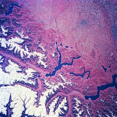
| Æмбарынгæнæн | Several elongated lakes (dark features) are identifiable in this southerly view of the Italian-Swiss border. The elongated lakes are the creation of alpine (or valley) glaciers that moved generally southward through this section of the Italian Alps over 12000 years ago. From west to east the four larger lakes are Maggiore (lower right corner), Lugana, Como, and d'Iseo (upper left corner). Smaller lakes (also dark features) are visible at the southern end of Lake Como (center of image) and Lake Maggiore. Subtle faults that are perpendicular to the southern end of the lakes can be traced east to west across the landscape at the base of the Italian Alps. Glaciated, U-shaped valleys are discernible north and northeast of the lakes. The color infrared helps to identify the densely vegetated mountain slopes where the forested land (green vegetation) is shown as concentrations of reddish patterns. The relatively flat plains of the highly industrialized and agriculturally productive Po River Valley (upper third of image) presents a dramatically different looking terrain than the snow covered mountainous region of northern Italy. |
| Датæ | Winter/Spring 1997 |
| Равзæрæн | Here |
| Сфæлдисæг | Image Science and Analysis Laboratory, NASA-Johnson Space Center. 18 Mar. 2005. "Earth from Space - Image Information." |
Это изображение или видеозапись внесены в каталог одного из исследовательских центров НАСА под идентификатором (Photo ID): NM23-776-834. Этот шаблон не указывает на правовой статус данной работы. По-прежнему необходим нормальный шаблон лицензий. См. Commons:Лицензирование. Другие языки:
|
Лицензи
| Этот файл находится в общественном достоянии (англ. public domain), так как он был создан NASA (Национальным управлением по аэронавтике и исследованию космического пространства). Политика авторского права NASA гласит, что «Материал NASA не защищается авторским правом, если не указано иное». (См. Template:PD-USGov, страницу политики авторского права NASA или политику использования изображений JPL.) | ||
 |
Предупреждения:
|
Файлы истори
Ныххæц датæ/рæстæг-ыл, цæмæй фенай еуæд куыд фæзындис.
| Датæ/рæстæг | Къаддæргонд | Барæнтæ | Архайæг | Фиппаинаг | |
|---|---|---|---|---|---|
| нырыккон | 21:18, 24 июлы 2023 | | 4055 × 4055 (15,2 МБ) | Don-vip | |
| 19:05, 5 августы 2006 |  | 639 × 639 (391 КБ) | Lange~commonswiki | {{Information |Description= Several elongated lakes (dark features) are identifiable in this southerly view of the Italian-Swiss border. The elongated lakes are the creation of alpine (or valley) glaciers that moved generally southward through this sectio |
Файлæй архайд
Ацы файлæй иу фарс дæр пайда нæ кæны.
Ацы файлæй куыд пайда кæнынц
Данный файл используется в следующих вики:
- Использование в ar.wikipedia.org
- Использование в arz.wikipedia.org
- Использование в ast.wikipedia.org
- Использование в az.wikipedia.org
- Использование в bg.wikipedia.org
- Использование в ca.wikipedia.org
- Использование в cy.wikipedia.org
- Использование в de.wikivoyage.org
- Использование в diq.wikipedia.org
- Использование в fi.wikipedia.org
- Использование в fr.wikipedia.org
- Использование в fr.wikivoyage.org
- Использование в ga.wikipedia.org
- Использование в gd.wikipedia.org
- Использование в gl.wikipedia.org
- Использование в he.wikipedia.org
- Использование в hy.wikipedia.org
- Использование в ia.wikipedia.org
- Использование в id.wikipedia.org
- Использование в ilo.wikipedia.org
- Использование в it.wikipedia.org
- Использование в ka.wikipedia.org
- Использование в ku.wikipedia.org
- Использование в la.wikipedia.org
- Использование в mzn.wikipedia.org
- Использование в nn.wikipedia.org
- Использование в no.wikipedia.org
- Использование в oc.wikipedia.org
- Использование в pl.wikipedia.org
- Использование в ro.wikipedia.org
- Использование в ru.wikipedia.org
- Использование в ru.wikinews.org
- Использование в sl.wikipedia.org
- Использование в sr.wikipedia.org
- Использование в tt.wikipedia.org
- Использование в uk.wikipedia.org
- Использование в vec.wikipedia.org
- Использование в vi.wikipedia.org
- Использование в www.wikidata.org