
Файл:150132main image feature 589 alaska.jpg

Оригиналы файл (5600 × 4400 пикселы, файлы уæз: 6,63 МБ, MIME тип: image/jpeg)
Ацы файл у ВикиКъæбицæй ист. Йæ урдыгон афыст у æвдыст дæлдæр. ВикиКъæбиц у сæрибар медиа файлты репозиторий. Дæ бон у баххуыс кæнай. |
Афыст:
| Æмбарынгæнæн |
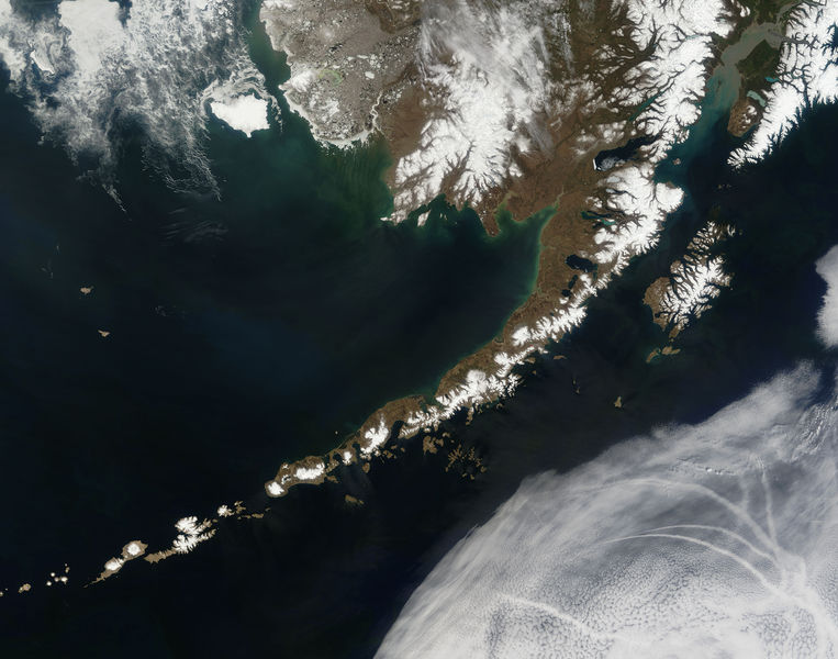
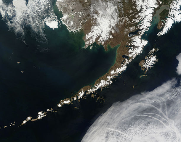
English: Satellite picture of the Aleutian Islands and the Alaska Peninsula, located in the south of the state of Alaska, United States.
Português: Imagem de satélite das Ilhas Aleutas e da Península do Alasca, localizadas no sul do estado do Alasca, Estados Unidos.
Original caption — The Aleutian Islands and the Alaskan peninsula are shown in this image acquired by the MODIS on the Terra satellite, on May 25th, 2006. The Aleutians are a chain of more than 300 small volcanic islands forming an island arc in the Northern Pacific Ocean. They extend about 1,200 miles westward from the Alaskan Peninsula. Nearly all of the islands are part of Alaska, but at the extreme western end of the archipelago are the small, geologically-related, but remote Komandorski Islands, which are considered part of Russia. The Aleutian Islands, with 57 volcanoes among them, are in the northern part of the Pacific Ring of Fire.
|
| Датæ | 25 майы 2006 |
| Равзæрæн | NASA (Image galleries) |
| Сфæлдисæг | National Aeronautics and Space Administration (NASA) |
| Æндæр фæлтæртæ |
.jpg)
Оценка
This image was selected as picture of the day on Wikimedia Commons for 2 September 2006. It was captioned as follows: Other languages:
Bân-lâm-gú: Ùi thài-khong koàⁿ Aleutian Kûn-tó kap Alaska Poàⁿ-tó Čeština: Aleutské ostrovy z oběžné dráhy. Cymraeg: Delwedd o'r gofod o'r Ynysoedd Aleutia a'r Gorynys Alaska. Magyar: Az Aleut-szigetek és az Alaszkai-félsziget az űrből nézve Polski: Aleuty i półwysep Alaska widziane z orbity ziemskiej Slovenščina: Aleutski otoki iz vesolja. |
Лицензи
| Этот файл находится в общественном достоянии (англ. public domain), так как он был создан NASA (Национальным управлением по аэронавтике и исследованию космического пространства). Политика авторского права NASA гласит, что «Материал NASA не защищается авторским правом, если не указано иное». (См. Template:PD-USGov, страницу политики авторского права NASA или политику использования изображений JPL.) | ||
 |
Предупреждения:
|
Файлы истори
Ныххæц датæ/рæстæг-ыл, цæмæй фенай еуæд куыд фæзындис.
| Датæ/рæстæг | Къаддæргонд | Барæнтæ | Архайæг | Фиппаинаг | |
|---|---|---|---|---|---|
| нырыккон | 19:55, 14 июлы 2006 | | 5600 × 4400 (6,63 МБ) | Felipe Menegaz | {{Information| |Description= The Aleutian Islands and the Alaskan peninsula are shown in this image acquired by the MODIS on the Terra satellite, on May 25th, 2006. The Aleutians are a chain of more than 300 small volcanic islands forming an island arc in |
Файлæй архайд
Ацы файлæй пайда кæны иу фарс:
Ацы файлæй куыд пайда кæнынц
Данный файл используется в следующих вики:
- Использование в af.wikipedia.org
- Использование в als.wikipedia.org
- Использование в bn.wikipedia.org
- Использование в ca.wikipedia.org
- Использование в cs.wikipedia.org
- Использование в de.wikipedia.org
- Использование в eo.wikipedia.org
- Использование в es.wikipedia.org
- Использование в fr.wikipedia.org
- Использование в gl.wikipedia.org
- Использование в hu.wikipedia.org
- Использование в ia.wikipedia.org
- Использование в it.wikipedia.org
- Использование в ja.wikipedia.org
- Использование в ko.wikipedia.org
- Использование в oc.wikipedia.org
- Использование в pl.wikipedia.org
- Использование в pl.wiktionary.org
- Использование в pt.wikipedia.org
- Использование в ro.wikipedia.org
- Использование в ru.wikipedia.org
- Использование в ru.wikinews.org
- Использование в sah.wikipedia.org
- Использование в sk.wikipedia.org
- Использование в sr.wikipedia.org
- Использование в sv.wikipedia.org
- Использование в tr.wikipedia.org